


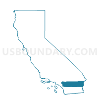
Voting District 44600, Riverside County, California
About
Outline

Summary
| Unique Area Identifier | 537945 |
| Name | Voting District 44600 |
| County | Riverside County |
| State | California |
| Area (square miles) | 609.81 |
| Land Area (square miles) | 609.81 |
| Water Area (square miles) | 0.00 |
| % of Land Area | 100.00 |
| % of Water Area | 0.00 |
| Latitude of the Internal Point | 33.55109180 |
| Longtitude of the Internal Point | -115.27428250 |
Maps


Graphs
Select a template below for downloading or customizing gragh for Voting District 44600, Riverside County, California


Neighbors
Neighoring Voting District (by Name) Neighboring Voting District on the Map
- Voting District 40125, Imperial County, CA
- Voting District 40150, Imperial County, CA
- Voting District 44045, Riverside County, CA
- Voting District 44055, Riverside County, CA
- Voting District 44145, Riverside County, CA
- Voting District 44200, Riverside County, CA
- Voting District 44205, Riverside County, CA
- Voting District 44535, Riverside County, CA
- Voting District 44775, Riverside County, CA
- Voting District 50215, Imperial County, CA
Top 10 Neighboring County Subdivision (by Population) Neighboring County Subdivision on the Map
Top 10 Neighboring Place (by Population) Neighboring Place on the Map
Top 10 Neighboring Elementary School District (by Population) Neighboring Elementary School District on the Map
Top 10 Neighboring Secondary School District (by Population) Neighboring Secondary School District on the Map
Top 10 Neighboring Unified School District (by Population) Neighboring Unified School District on the Map
- Coachella Valley Unified School District, CA (85,553)
- Palo Verde Unified School District, CA (24,294)
- Calipatria Unified School District, CA (10,397)
- San Pasqual Valley Unified School District, CA (3,464)
- Desert Center Unified School District, CA (242)
Top 10 Neighboring State Legislative District Lower Chamber (by Population) Neighboring State Legislative District Lower Chamber on the Map
Top 10 Neighboring State Legislative District Upper Chamber (by Population) Neighboring State Legislative District Upper Chamber on the Map
Top 10 Neighboring 111th Congressional District (by Population) Neighboring 111th Congressional District on the Map
Top 10 Neighboring Census Tract (by Population) Neighboring Census Tract on the Map
- Census Tract 9810, Riverside County, CA (7,634)
- Census Tract 469, Riverside County, CA (2,043)
- Census Tract 124, Imperial County, CA (1,266)